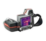
Detail CMT MARCH IIE Precission GPS/ GIS Receiver System
• Small, integrated unit, very convenient and easy to carry.
• Rugged and waterproof construction.
• Used by many forest companies as a multi-purpose GPS tool. Popular in the GPS/ GIS market.
• Easy field battery replacement ( no tool required) .
• Simple 14-key format and Field 3.8 makes it easy to learn and collect complex GPS/ GIS data.
• Powerful PC-GPS included, standard.
The MARCH is a compact, cost effective, integrated GPS/ GIS data collector, ideal for small data collection jobs. It has enough memory for a typical full days work. The internal 8 channel GPS receiver provides 1-5 meter accuracy with real-time or post-processing differential correction. This unit has most of the same features as the MC-GPS - it utilizes the same Field 3.8 and PC GPS Software Ver. 05, has two COM ports, and is available with a Carrier Phase option. Even though it does not have a full alpha numeric keyboard, data collection lists can still be created on the handheld using a pop-up alpha numeric menu. However for speedy creation of data collection lists it is recommended you create the lists on a PC with the PC-GPS Ver. 05 software before heading out to the field.
CMT March-II-E Standard Packages includes: 8 channel GPS Receiver, Field Software Ver. 3.8, PC-GPS Software Ver. 05, 2MB Standard memory, Nylon carrying case, PC transfer cable, Spare MARCH Battery and Spare MARCH battery recharger.
Data Collector Features
- Waterproof ( submersible)
- Operating temperature: -20° C to 54° C
- Audible beeper
- 8 line x 21 character backlit display
- 2 MB RAM, 512K Flash EPROM
- 7.9 " ( 20 cm) x 3.9 " ( 9.9 cm) x 3.0 " ( 7.62 cm)
- Fully integrated GPS receiver, antenna and data collector in one hand-held unit
- 14-key keyboard including 5 function keys
- External antenna port
- Up to 5 hrs. on internal, rechargeable battery
- Field-replaceable rechargeable battery
CMT Field Software v3.8
- Collect Points, Lines Areas
- Feature/ Attribute/ Value GIS structure
- Graphic plotting.
- Offset function to map hard-to-reach locations.
- Nested point function for tagging points while you are mapping a Line or Area Feature.
- Averaging function to optimize accuracy while recording static points.
- LLA/ UTM/ SPC plus user-defined coordinates.
- Supports 50 datums plus user-defined datums.
- On-board area calculation
- Built-in traverse
Tampilkan Lebih Banyak